Most hikers believe a GPS is just for dropping pins and following lines. But when you’re halfway up a cloud-covered ridge with zero phone signal and a map turning to mush in your pocket, you realise just how much depends on your kit. I found that out the hard way near Glen Coe – phone battery gone, touchscreen rain-soaked, and no idea which way was back to camp.
That’s why I’ve switched to using a dedicated outdoor GPS, and the Satmap Active 20 is one that’s earned its keep. It’s not flashy. It’s not trying to be a smartphone. But when the weather’s foul and the path disappears, it just works – and sometimes, that’s all that matters.
This review digs into its real-world performance, durability, and whether it’s the right bit of kit for your next adventure.
The Satmap Active 20: What Is and Who Is It for?
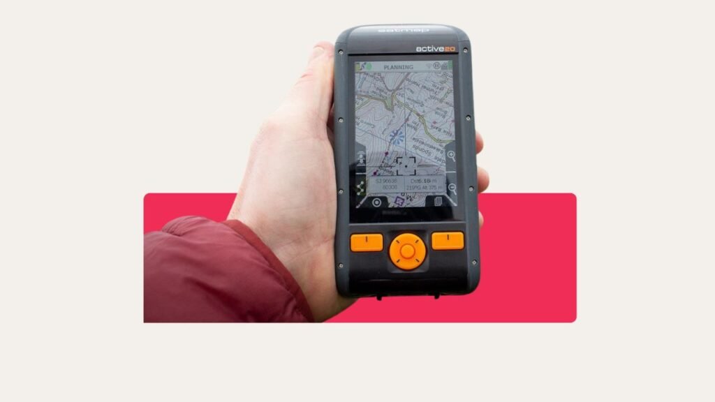
The Satmap Active 20 is a rugged, handheld GPS designed for people who take the outdoors seriously. Think of it as your paper OS map’s smarter, tougher cousin – the one that doesn’t get soggy, blow away, or give up when the signal drops.
It’s built for hillwalkers, wild campers, mountain bikers, and off-grid explorers who need rock-solid navigation no matter what the British weather throws at them.
This isn’t for casual strolls with a café at the end. The Active 20 is for those who want pinpoint accuracy, proper OS mapping, and a device that can take a beating. If you’ve ever felt let down by your phone’s GPS in the middle of nowhere, this is the upgrade that earns its place in your pack.
Technical Specifications – What You Get in the Box
You get a 3.5-inch sunlight-readable touchscreen, backed up by tough Gorilla Glass. The buttons are proper tactile jobs you can press with winter gloves. The GPS accuracy claims 1-2 metres – good enough for zero faff on featureless moors or dense woods in Derbyshire.
Battery? It comes with a rechargeable LiPo cell, and you can use AAs in a pinch. Proper water and dust resistance – IP68 rated. It even connects to Bluetooth sensors (heart rate, cadence) and supports both GPS and Galileo satellites, so you’re unlikely to lose your position, even in nasty Scottish tree cover.
Weight is 312 grams – a brick compared to a phone, but miles more rugged.
Satmap Active 20: Construction and Design
No sugar-coating it: the Satmap Active 20 is bulky. It won’t slip into your running vest’s pocket; this lives on your belt or deep in your rucksack. It’s about the size and shape of an old pager – solid and confidence inspiring.
On the plus side, you’ll struggle to break it. I’ve dropped one down a scree slope – the Gorilla Glass survived, screen unscathed. The casing is tough, black plastic with a few orange buttons, and while it won’t win a beauty contest, it looks like it’s ready for real work. The rubber flap over the USB port feels soft, so keep an eye on it – mine loosened after some use.
Waterproof? It’s more than splash-proof, so don’t panic about a dunking or a day in the Lakes. The IP68 rating means you can forget about a ruined GPS after a soggy night. Just make sure the bungs stay closed.
The Control System
Satmap got it right with their control scheme. The screen works much like a smartphone for zooming and panning maps. But unlike your phone, it has big physical buttons down each side for basic menu access, scrolling, and selection.
When your hands are numb in winter wind or midge nets get tangled, those buttons are priceless. No more stabbing clumsily at a touchscreen that doesn’t register damp gloves. I’ve adjusted routes in hail on the Glyders – buttons always worked.
You quickly learn which does what; the menu flow is logical and doesn’t demand a degree in tech.
Mapping and Navigation Quality
The Satmap Active 20 shines for mapping detail, especially with Ordnance Survey maps loaded. You get street-level detail down to 1:10,000, and trail accuracy that leaves open-source maps in the dust. If you know your way around a Land ranger or Explorer map, you’ll feel right at home.
Screen clarity is decent in most conditions. In cloud or mottled woodland, it’s a joy. When the sun blazes at noon, expect a bit of squinting. It’s brighter than past models, but not immune to glare. On a sunny day above Ullswater, I sometimes wished for a paper map out of habit—but for route planning and tracking, the detail wins.
Map scrolling is fast. You won’t see any lag zooming or skipping across long trails. Tracks and waypoints are quick to save, so you don’t miss a turn even if the weather is closing in.
GPS Accuracy and Reception
Some GPS devices start acting up the moment the clouds roll in or you duck under tree cover. Not the Satmap Active 20. This thing locks on like it means it, even under thick Welsh woodland, sideways Highland rain, or awkward urban fringes where signals usually go fuzzy.
It taps into both GPS and Galileo satellites, so you’re not left waiting for a signal while your mates crack open snacks. Most of the time, it’s accurate within a couple of metres, which is exactly what you want when you’re picking your way through fog, ferns, or featureless hillsides. It just works – no fuss, no spinning blue dot.
Battery Life in the Wild
If you’re just tracking routes or checking your position every hour, the Active 20 will last through a decent mountain day – maybe 12 to 16 hours in my experience. Hammer the backlight and it drops off, but the sleep mode helps stretch things. Unlike some rivals, the screen fully shuts off, saving power for when you need it.
You can carry a spare LiPo or pop in some AAs. I always pack a few AAs in the first aid kit – crisis solved if things go wrong. The weak spot: you can’t fully turn off the backlight while using it, so be mindful when idle.
Route Planning and Software: Xpedition 2
Route planning is through Satmap’s Xpedition 2 platform. It’s browser-based and does a good job for marking out walks, bikes, or paddles. But – and it’s a big but – the best bits need you to pay for a subscription. Some folk grumble at this, especially with free phone apps about.

Transferring a route onto the device isn’t as quick as the Garmins or your smartphone. You’ll use a USB cable and Satmap’s own format. It’s not hard, just more “old-school.” I recommend sorting routes before heading out; faffing in a tent during a downpour is no fun.
Sharing or exporting tracks works, but again, don’t expect it to sync as easily as modern smartwatches or cloud-based rivals.
Pros and Cons – What Matters in the Field
Value for Money
This isn’t a budget GPS. The price is comparable to the Garmin Montana 700 or a top-end Suunto watch. But you’re paying for British-centric mapping, burly build, and those glove-friendly controls.
If you hike, camp, or bike most weekends – even in foul weather – it’s worth considering. If your GPS only comes out once a year, or if you never leave marked paths, your money might go further with a simpler model.
Compared to the Garmin Oregon 700, the Satmap wins on UK mapping and durability; Garmin wins on slickness and global features.
Final Thoughts – Should You Pack the Satmap Active 20?
So, should the Satmap Active 20 earn a place in your rucksack? If you’ve ever battled through a whiteout or found yourself second-guessing your route in the middle of a downpour – yes. It’s built for the wild stuff. And if you’re leading others or just like knowing exactly where you are, the confidence it brings is worth every gram.
That said, if you mostly stick to local trails, prefer app-based nav, or recoil at the thought of plugging something into your laptop, this might feel a bit old-school. But for the rough, wet, windy unpredictability of UK camping and hiking, it’s still one of the most reliable tools you can carry.
It won’t stop the weather or solve every problem, but it will keep you found. And when the clouds roll in and the light starts fading, that matters. Just don’t forget to bring spare batteries, a solid waterproof, and a good sense of humour. That’s proper British camping kit.